Wednesday, 13 May 2009

Canoeing down the Ardèche Canyon.

Just an hour's drive from my house in Provence, the Ardèche Canyon and River offer superb hiking and canoeing opportunities. Several companies organize the descent of the river by canoe, providing canoe rental and van transfer back to the start, in the village of Vallon Pont d'Arc. It costs about 20€ per person, which isn't bad considering you're out all day... You can choose to canoe through 8km, 24km, or all 32km of the canyon river. Christine and I chose the full 32km...

Here's me in the back letting Christine do all the work while I snap photos. We are about to cross under the Pont d'Arc, a natural limestone archway above the Ardèche river.


The river snakes its way eastward, through breathtaking scenery. Jagged and rocky cliffs line both sides of the river while forested hills paint the backdrop.


Here is one of the highest cliffs, appropriately named La Cathédrale (can you make out a cathedral?). Christine and I had our lunch here after about 4 hours of paddling... There are plenty of spots to pull over and have a bite on the banks, or a swim in the cool waters.

Here I am doing a few circles as Christine rests on the bank...
A picture of our canoe as we take a rest after 5hours of paddling.... Does this canyon ever end?


Luckily there are a few rapids to help us along the course. Not too technical, they provide some excitement every few kilometres... Below is a video of Christine and I negotiating one of the rapids...


Thursday, 7 May 2009

National Park of Port Cros, French Riviera

Port Cros is an island a few nautical miles south of the French Riviera, near St. Tropez. The ferry departs several times daily from the quaint Riviera town of Le Lavandou, seen below:


A view of the island from the ferry: about 3km long and 2km wide, the island of Port Cros is the smallest of a set of three islands called the "Golden Islands", or "Iles d'Or". Protected as a national park since the 60s, the island is a veritable walking paradise: no cars, no construction, no smoking -- only a set of beautiful walking paths carved into the rocky coastlines and island interior.


Here is the island port: a tiny set of of homes and a year-round population of only 30. Construction on the island completely stopped when it was converted into a park. You can find a handful of restaurants and bars here to have a bite or a drink once you've finished exploring the island.


Even the waters are protected in this National Park: no fishing allowed. This picture below was taken by the main port. These guys were looking for pieces of baguette thrown into the waters by a group of schoolchildren:


Here is one of the few pre-Napoleonic forts on the island, built to protect France's southernmost outpost against invaders, such as the English (no offence)


Leaving the port, the wilderness becomes untamed and the waters crystal clear. In this picture an Aleppo pine stands proudly by the coastline...


There are two classic walking options on the island: an eastern or western loop, both lasting about 4 hours. I began on the eastern portion, slightly more challenging. Steps are carved into the hillside -- as seen below -- carrying you quickly above sea level and back down.


Shaded by giant cork trees and dense vegetation, the island is a reminder that Mediterranean forest can be lush when left to its own devices. On the mainland the vegetation is mostly composed of brush due the continuous depletion of soils


Too eager to take pictures, this guide forgot to watch his footing and had a fight with a boulder -- and lost...


On the north side of the island, facing the mainland, the paths remain close to sea level, making it easier to observe the pristine waters


Here is another shot of the coastline path along the eastern loop. Since the island only attracts walkers -- not the beachgoers of the mainland -- you can often walk for hours without seeing a single person. As was the case for me today.


You can take the time to explore the beautiful inlets...

Speaking of beautiful inlets, here's a little video...


It's early May and flowers are out in full force. Below are: wild lavender, Hottentot fig, thistle, cistus, asphodele.


Heading back toward the west, an easy path on a wide track leads the way: a soothing portion to ease the knees after all those steps.

I saw many uprooted pine trees along the way: this past winter there were some major storms and some of the trees, having shallow root systems in their Mediterranean soils, did not resist...


The ruins of the building called La Sardinière in the island interior, slowly being taken over by plants and trees...


A final climb on the west side of the island leads to its 200m summit -- Mont Vinaigre -- from where the picture below was taken. I found my lunch spot here, under the shade of an arbutus tree.


The southern slopes seen here are much more jagged than on the north: a beautiful path runs on a shelf high above the sea, with outstanding and far-reaching views.

The shaded paths leading back down towards the port are soft underfoot...

After some rains this Spring, this valley path was blanketed by a stream, which will dry by the summer....

blog you later,

Stuart

Wednesday, 6 May 2009

Cycling above the French Riviera

Hi everyone,
Sorry for the long blog-less absence; I've been under the weather recently. I'm back in France after two months in Canada and am awaiting my Spring guiding season impatiently. So instead of twirling my thumbs today, awaiting my first group on Sunday, I decided to test my work tools (legs) on a bike ride. Based in the quaint town of Le Lavandou on the French Riviera, I cycled up towards the perched village of Bormes les Mimosas. The town is very pretty, its narrow streets laden with exotic flowers, especially mimosa... Below is a picture of the town.


Continuing the climb out of the village, the views of the Mediterranean become outstanding... You can see the island of Le Levant in the background: a nudist colony since the early 20th century. Unfortunately I didn't bring my binoculars...


And before long I found myself in the mountains, blanketed with cork trees and wild flowers... The road winds its way through forest with steep cliffs and blind turns, which didn't stop two motorcyclists from passing me as if they were on a speed track (they are French after all).

Here I am at the top of the pass -- Col de Babaou -- sweaty but satisfied... now it's time to turn around and coast 15km downhill...


Speaking of coasting downhill, here's a little video. I don't recommend cycling downhill on a treacherous road while videotaping, but I couldn't help myself...


Back in Bormes les Mimosas, nearly finished my descent, I figured my efforts could be rewarded with some ice cream...


Blog you soon,
Stuart

Thursday, 8 January 2009

Snow in Provence?

This is the fist snowfall around Avignon in 5 years, and more snow than I've ever seen in Provence. Below is a picture of my village - Chateauneuf de Gadagne - taken yesterday.

Some of the vineyards of Chateauneuf de Gadagne, blanketed by the snow. Generally, "snow" in Provence is just a few flakes: the kids rush outside for about an hour to try and play with it before it melts, then they wait patiently until next year. But those lucky kids were able to play in it yesterday and today, seeing that all the buses were cancelled due to 10cm of snow...

Indeed, there isn't a single snowplow in Provence, though I did manage to snap this shot of an ingeniously improvised plow, fashioned out of a tractor normally used in the vines... I was stuck in Avignon yesterday without public transportation to return to my village: the afternoon buses had been cancelled and so I decided to cycle home on the snow. I managed far better than the cars I saw sliding all over the road and getting into accidents.
A view from atop my village, looking out toward the plains...

Snow cacti?

A walking path in my village...

Here's a picture of Christine in front of our home, and the bike I had just ridden from Avignon.


Monday, 15 December 2008

Mont Ventoux in Tour de France !!!!!!!!!!!!!!!

Summit of Mont Ventoux, seen from the forest halfway up the mountain


It will happen July 25th, 2009. I’ve been waiting patiently for seven years, and after weeks of speculation and rumour it has been confirmed. YES: my favourite Provençal mountain, my playground, my 2000-meter-high-or-almost-deity (the “almost” applies to both “2000” and “deity”), will play host to the world’s most prestigious cycling event. Mont Ventoux, after a seven year hiatus, will once again be part of the Tour de France. Not only is the climb to Ventoux going to be part of the Tour, but its ascension will take place on the second to last day – which is the most important stage – as it will permanently lay the yellow jersey on the overall winner of the 2009 Tour de France. We can then safely multiply the Ventoux excitement factor by ten. Add to the mix a certain Lance Armstrong, who is in all likelihood going to participate in this year’s Tour de France after announcing that he’s come out of retirement. This leads to an immeasurable Ventoux excitement factor, an excitement hitherto unseen on the slopes of my favourite place on Earth.

An insight into the extent of Ventoux-Armstrong-Tour-de-France-mania: as of the very first days of the rumours that Ventoux was to be part of the 2009 Tour, and this probably about 2 months ago, any form of accommodation within a 50km radius of the mountain was overwhelmed with phone calls and booked solid, and this before the official announcement was made...

VENTOUX and CYCLING:
There are three roads leading to the summit, all of which are more or less tough. The two classic climbs – the south and north routes – are comparable, each starting at about 300m in altitude and rising to the 1912m summit over a stretch of 21km. The average gradient of incline is 7.5%. To put the climb into perspective, it’s the same altitude gain as the Colorado river up to the rim of the Grand Canyon (for my American friends), or like scaling the CN Tower three times to its very tip (for my fellow Canadians). Sorry to my UK, Aussie, and Kiwi friends for analogy omissions.

The climb from the east -- from the village of Sault -- starts at 800m in altitude, and reaches the summit over a span of 26km, a slightly easier gradient.

Ventoux is a Mecca for cyclists, as the New York marathon would be on a runner’s checklist. On a nice summer day, anywhere from 200 to 500 (or more) cyclists make their way to the summit by bike, attempting to conquer the “Giant of Provence”.

This is me on my 30th birthday, having tackled the summit in two and a half hours. The record was set by the Spaniard Iban Mayo, who reached the summit in just over 55 minutes during a week-long stage race called the Dauphiné Libéré. I was probably passed by 300 cyclists that day.


Some notes on the history of cycling on Ventoux:

A weather station, created atop Ventoux in the late 19th century, required a road to be built to the summit. As early as 1882, amateur cyclists were eager enough to try and conquer the mountain by bike, testing their legs on the steep dirt road. The first ever race to the summit was held in 1908, linking the nearby town of Carpentras to the summit. A local lumberjack, on a bicycle without gears, won the race at the summit in 2 ½ hours. The road conditions have since improved, as have the bikes.

The Tour de France, whose itinerary changes every year, has included the summit of Mont Ventoux 13 times in all: 5 finishes at the summit, 6 passages to the summit, and 3 time trails. The first was in 1951, during a 224km stage between Montpellier and Avignon, won by Louison Bobet.

The most memorable moment of Tour de France history at Mont Ventoux was certainly the most tragic: in 1967, the English champion Tom Simpson, who kept on slowing near the top of the climb, and began to zigzag across the road, fell to the ground just 2km from the summit. Fans on the side of the road hoisted him back up on his bike and tried to get him going, but he fell just as soon, unconscious, and did not reawake. It was a particularly hot day in July, and as usual the cyclists were out during the hottest hours of the day. But Simpson’s cardiac arrest was probably due to the cocktail of alcohol and amphetamines he had consumed, used by many cyclists at the time. His final meters: http://www.youtube.com/watch?v=YtAyGvZqiwk&NR=1
Me at the Tommy Simpson Memorial, 2km from the summit; as you can see, many cyclists offer Tommy a token, often a water bottle, on their way back down the mountain.

French fans, proud of their own cyclists, will remind you that Lance Armstrong, although arguably the best cyclist in Tour history, has never won (yet?) at the summit of Ventoux after 6 tries in competitive races (not just the Tour). In 2000, having already secured the yellow jersey and an overall victory, he let Marci Pantani cross the finish line at the summit first (despite Pantani’s claim otherwise).

The last time Ventoux was included in the Tour was in 2002, where Lance once again placed second in the stage, behind France’s Richard Virenque. Armstrong had the fastest time from the foot to the summit, but Virenque had broken away earlier in the day, and he would not be caught.

Here's a picture I took of Lance Armstrong in the last stage he won as a professional in the Tour, during the 2005 time trial in St. Etienne... a bit blurry but we'll fault the camera.


Anyone care to join me on Ventoux on July 25th? You can count on me being there.

Sunday, 7 December 2008

Cycling in Alsace? (and not hiking in Provence?)

I was recently in the Alsace region of France (north-east), putting together a cycling holiday for a British company called Inntravel: they specialize in self-guided walking and cycling holidays. I've worked on several projects for them, whether cycling or walking, writing detailed trip notes that guide their customers through the paths and back roads of various French regions.

You may be wondering why, as a walking guide in Provence, I'm writing to you about my cycling expeditions in Alsace. Though I still prefer my beloved Provence, and wouldn't trade it for all the baguettes and Camemberts in France, my travels keep proving how wonderfully beautiful and diverse a country this is.

I was in Alsace a month ago, nearing the end of October. Based in the quaint towns of Bergheim and Kaysersberg, I set out every day by bike, exploring country roads through reputed vineyards. It was nearing the end of the grape harvest, the vines all yellowish gold, planted in strict geometric parcels that cover the foothills of the Vosges Mountains. Below is a bunch of Gewurztraminer grapes, one of the last of the varietals picked, often left longer on the vines to produce a sweet late-harvest wine. I have to admit that I ate quite a few whenever the opportunity arose, enough sugar to propel me from town to town. This was mainly to counteract the effects of the wine tasting I did along the way. Dozens of family-run wine estates in and around each town, in centuries' old cellars, always welcoming. Most estates produce each of the seven types of wines, the only region in France to produce wines by varietal and not by blending.

I enjoyed the Gewurztraminers the most, with their aromas of ripe exotic fruit and sweet taste.


The Alsatian villages seem to pop out of a fairy tale book: colourful half-timbered homes snuggled side-by-side, ancient bridges and cobbled streets, old city walls still intact. Their names, often ending in "heim" or "berg" or "wihr", attest to a past under German rule. In the streets you can still hear the language of Alsatian spoken, while the accent in French has a distinct Germanic tone. Below is a picture of the town of Kaysersberg, picturesque and welcoming.


A few of the half-timbered homes in Bergheim below. Bergheim is off the beaten tourist track, full of charm and with a wonderful little hotel to stay in as a base.

Below are some of the reputed vineyards, which is what made up the backdrop of most of the scenery during the week. Unlike Provence, some of the tracks in between the vineyards are actually paved or cemented, and off-limits to motorized vehicles: a paradise for cyclists. There's a downside to cycling in the region though: the vineyards stretch out as a very thin line along the foothills of the Vosges mountains. A bit to the west and you have to tackle some killer hills in the mountains, a bit to the east you are in the Rhine valley, with relatively uninteresting scenery and extremely busy roads. So you more or less have to stay within that thin line, and sometimes even cycle out and back along the same itinerary, but well worth it nonetheless.

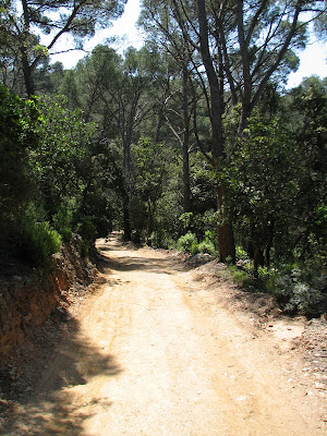
Part of the planned itinerary does leave the vineyards, down to the cornfield and forested flatlands of the Rhine valley. Here the scenery changes abruptly. You can find little hidden side roads where you won't see a single car all day, through vast expanses of forest (at least by French standards). Below is a picture taken along one of those roads.
Some grapes being picked during my last day of cycling...